
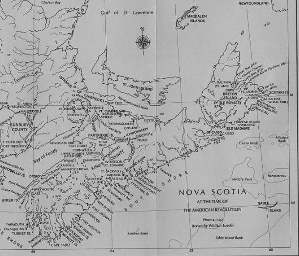
In 1759, Lawrence and his Council projected fourteen townships: Tinmouth (New Dublin), Liverpool, Barrington, Yarmouth, Annapolis, Granville, Horton, Cornwallis, Falmouth, Onslow, Truro, Cumberland, Amherst, and Sackville (see map). Overall, between the years 1760 and 1763, about 4,500 people came to settle these townships, mostly, as we have seen in the previous chapter, to settle down on those lands which had been previously occupied by the Acadians and which today we know in Nova Scotia as the Annapolis Valley. By 1763, Nova Scotia had significantly increased the number of English communities, which, prior to 1760, had only really been one, that of Halifax (Lunenburg being then yet a German speaking community, and Annapolis Royal and Windsor having only small garrisons of English soldiers.)1
In 1763, DesBarres, an army Engineer and the then Quarter Master General, was to give a description of Nova Scotia and its settlement.2 Westward from Halifax was Chester and then Lunenburg.3 DesBarres described Lunenburg as "a flourishing settlement of laborious and industrious people." Lunenburg as a settlement was then ten years old. The founding population of Lunenburg had come from central Europe, and while in successive generations they were to become experts at earning their living from the sea, in the early years they stuck to the business of farming. DesBarres was to observe in 1763 the "Township of Lunenburg shipt 1500 bushells of Roots besides several other Articles rais'd on the Farms of the Settlers this Settlement is so astonishingly healthy" that in a period of 18 months 125 were born to only four deaths.
Leaving Lunenburg, the next community, in 1763, that one would have come to would be that which Lawrence and his Council, in 1759, had named Tinmouth, but which, for good reason was to become known as New Dublin. Irishmen had settled along the Dublin shore, just beyond where Frenchmen, under De Razilly, had first settled in 1632 and who had long since moved along to other parts. New Dublin had been one of two settlements made in Nova Scotia under the auspices of Colonel Alexander McNutt, the other was Londonderry, located on the north shore of Minas Basin near present day Truro.4 DesBarres, in 1763, was to write of New Dublin, "some Familys from the north of Ireland are settled here & have begun to clear Lands ..."5 Carrying along the Nova Scotian coast, westward again, the next communities to come upon would have been Liverpool and Cape Sable. As for Liverpool: well, we treat that in Chapter 7.
DesBarres then takes us along into the territory of the Annapolis Valley:
"On the banks of the River Annapolis two townships are lately settled [Annapolis and Granville], and as most of the lands were formerly under the cultivation of the Acadians they are in a very flourishing condition. They have a communication overland with the townships in the Bason of Minas & with Halifax but by a very bad path through the woods."Skirting the uninhabited (indeed, uninhabitable) northern shores of the Bay of Fundy, DesBarres next brings us to the Chignecto area by carrying up into the farthest reaches of the Bay. There one would have found Fort Cumberland which stood first through the years 1750 to 1755 as an eastern outpost of the French (then named Fort Beausejour), and which, by force of arms, in 1755, was to become an English fort. Fort Cumberland overlooked the western part of the 12 mile isthmus, the crossing over of which would bring one to Bay Vert (Northumberland Strait) and access to St. John's Island (Prince Edward Island, as we know it today). At the Isthmus of Chignecto three townships were marked out: Sackville, Cumberland and Amherst (see the the Morris map of 1760). I say marked out, for the occupation of the Chignecto area by the English was to come at a later date.
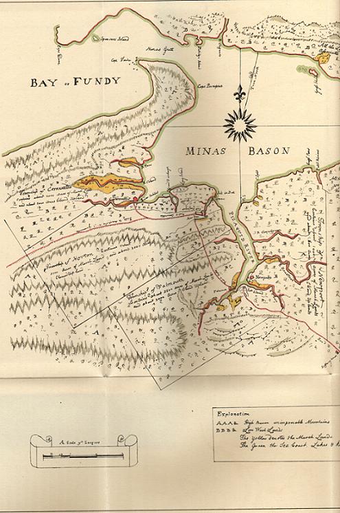
DesBarres then brings us to the end of our peninsular tour by going into the Minas Basin where there had been collections of industrious French people, the Acadians, who had worked their lands behind their dykes through the years, 1690-1755. Here, at the mouths of the rivers in the western end of the basin, were established the new English settlements of Newport6, Falmouth7, Horton8 and Cornwallis9; "all lately settled," by, needless to say, English farmers. Halifax could be reached overland from Newport, a forty mile trek (see the the Morris map of 1760) southeast over a path that had been long in existence "almost impassable the greatest part of the year and as yet impracticable for carriages of any kind." At the eastern extremities of Minas Basin, to complete the circuit, would be found the communities of Onslow and Truro (see the Morris map of 1760).
Since we have now touched upon the subject of roads in Nova Scotia, we should say, that in 1763, there were none. Indeed it was DesBarres' conclusion that there was no proper inland communication anywhere in the province. There was only the one path that extended from Annapolis to Halifax via the establishments at the western end of Minas Basin. The only way to get about in Nova Scotia in those days and for many years thereafter was by sailing vessel, a mode of transportation which depended on the direction of the wind, the height of the tide, and the season of the year. DesBarres "humbly propos'd" to the governmental authority that roads be built. That after turning the path from Annapolis to Halifax into a great road there then should be a road built "from Halifax westward by the townships of Chester, Lunenburg, New Dublin (LeHeve), Liverpool and even to Cape Sable and there through these settlements to Annapolis."10 The plans, not to be put into effect for many more years to come, were ambitious: "the breath of the road shall not be less then twenty-one feet and properly raised in the middle to carry off the water" with ditches on each side with proper outlets and drains. So, too, it was envisaged, that woods be cleared away on each side of the road one hundred feet, at least. DesBarres was of the view that a special army Corps of Engineers (Company of Pioneers) might be employed to carry out the work.
The fact of the matter was that the sea was to act as a natural highway of commerce for many years for Nova Scotia, as was the case for much of the world. In this regard, Nova Scotia had a distinct advantage, it being practically surrounded by the sea. Messages, however, were often moved over land. William A. Calnek:
"At this period the mails were carried from Halifax to Annapolis once every fortnight, and vice versa, partly on horseback and partly by a foot postman. A vehicle, other than the commonest carts, was a thing yet several years in the future. The winter was the joyous and truly enjoyable season of the year, for it was then that the "horse-sled" was put into requisition by old and young, the roads admitting its use, while, from their rude condition they refused to permit the transit of a wheeled carriage. It was therefore in this season that a round of visiting was planned and carried out, of visits to relatives in other townships, and friends in remote settlements ..."11
To conclude, we set forth a table listing the communities, circa 1763, which existed in Nova Scotia together with the estimated number of families and population level for each.
[NEXT: Bk. 2, Pt. 1, Ch. 5 - "The Early Settlement of the Chignecto Townships."]